)
)
)
)
)
)
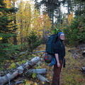
, we encountered many downed trees. After passing the junction with trail 480 (to Gumjuac Saddle), the size and frequency of downed trees increased dramatically, along with the density of surrounding brush. We finally broke clear of downed trees about 3/4 of a mile from Badger Lake. So, that's between 2 and 3 miles of downed trees, with more time spent going around trees than traveling on-trail.")
Note the many downed trees ahead. The beginning of serious trouble. - Note the many downed trees ahead. This was on trail 479 just before meeting trail 480. According to our map, trail 477 should have intersected around this point, but we never saw it. As soon as we passed the junction with trail 477A (Badger Creek Cutoff to Flag Point Trail 477), we encountered many downed trees. After passing the junction with trail 480 (to Gumjuac Saddle), the size and frequency of downed trees increased dramatically, along with the density of surrounding brush. We finally broke clear of downed trees about 3/4 of a mile from Badger Lake. So, that's between 2 and 3 miles of downed trees, with more time spent going around trees than traveling on-trail.
- Created on
- Saturday 17 October 2009
- Posted on
- Saturday 17 October 2009
- Albums
- Visits
- 5561
- Make
- OLYMPUS IMAGING CORP.
- Model
- E-620
- DateTimeOriginal
- 2009:10:10 17:35:41
- ApertureFNumber
- f/4.7